Warhammer 40,000 Map Icons v6.0

Being the tragic geek that I am, I spent several months last year coding up an interactive map of the Warhammer 40,000 galaxy. What I came up with worked beautifully in Firefox on my fairly grunty, fairly new computer, but like an absolute dog with any other setup, so I’ve had no choice but to go back and start over from scratch – a prospect so disheartening that it will be many, many months before I can bring myself to look at it again, if ever.

The upside of this failed project however is that I ended up doing a complete revision of my Warhammer 40,000 map icons. And when I say complete revision I mean a radical change in the way they’re organised. So radical in fact that I’ve decided to leave version 5.0 available in this post for those who might prefer them, while making the new version available here.

The major changes in version 6.0 include…

Separation of Environment, Class and Affiliation: There are now separate sets of icons for the environment of a planet, how it’s categorised by the Imperium (ie: what ‘Class’ it is), and who controls it.

Consistent Colours: Each major faction now has a consistent colour scheme rather than the previous hodge-podge, so it’s easier to see who controls what at a glance.

Consistent Shapes: The sizes and shapes of icons are standardised rather than being all over the place with bits sticking out the sides.

Meaningful Shapes: Five different icons shapes are provided to represent planets/moons, space stations, dwarf planets/asteroids, fields/swarms and fleets/ships.

I’ve also added sub-faction specific icons so you can differentiate between (for example) Biel-Tan Eldar and Iyanden Eldar, or Mephrit Necrons and Sekemtar Necrons, should that be your idea of a morally acceptable good time.

I present the icons here in three formats

SVG Version  This is the version to use if you know what you’re doing with Vector graphics. If you’re making your map in a vector editor such as Illustrator or Inkscape this is the superior option. If you’re not, then one of the PNG versions will probably be more convenient.
DOWNLOAD

White PNG – An export of the Icons on a flat white background.
DOWNLOAD

Black PNG – An export of the Icons on a flat black background with a white glow effect.
DOWNLOAD

I should probably add a transparent PNG version, shouldn’t I? Maybe tonight…

Anyway, share and enjoy!

Zanzibar, Oh Zanzibar!

So there I was, watching Joanna Lumley’s Spice Trail Adventure on free-to-air tv last night like the dinosaur I am while waiting for Annika to come on and reflecting that if they’ve killed Tosh on Shetland (on after Annika) I would be extremely annoyed when this thing appeared on my screen.

That’s no moon Zanzibar!

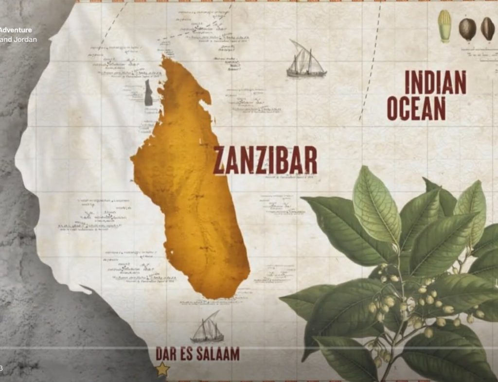
This – according to ITV – is a map of the east African island of Zanzibar. Now, I had never to my knowledge seen a map of Zanzibar prior to last night, but I was pretty sure it doesn’t look like that. And the reason I’m pretty sure it doesn’t look like that is because that is clearly a map of the much, much larger east African island of Madagascar.

What absolutely baffles me about this is how it could possibly have happened. Someone in the ITV graphics department obviously put time and effort into creating an accurate map of the area around Zanzibar, and then slapped a map of Madagascar into the middle of it. They even took care to not cover up the smaller island of Tumbatu just to the west. It surely can’t be a mistake. Is it some kind of protest? Some kind of prank? And how did it get through to the final product without anyone noticing it?

Just sheer bafflement all around. I’m tempted to shoot them off an email to try and get to the bottom of it. Do better ITV!

Warhammer 40,000 Map Icons

UPDATE! Version 6.0 of the icon set is now available, but it’s a radical departure from previous versions, so I’m leaving version 5.0 here for those who might prefer the old style. Version 6.0

Many years ago I purchased the rulebook for the now sadly defuct Fantasy Flight Warhammer 40k RPG Dark Heresy. While I thought the game was great I was rather annoyed by the poor quality of the planet icons used in the provided map of the Calixis Sector, and being the kind of obsessive nerd I am I couldn’t help but make my own version of if where you could tell what planet was what without having to use a bright light and a magnifying glass.

One thing led to another and by 2019 I’d produced an entire library of icons for 40k maps, free for anyone to use, which could be found on Reddit.

Recently someone contacted me having problems downloading the icons, so I decided it was time to make some updates, and post the files here where I know where to find them without having to sort through my rather chaotic Reddit history.

So here it is – Version 5.0, for your downloading pleasure!

SVG Version – This is the version to use if you know what you’re doing with Vector graphics. If you’re making your map in a vector editor such as Illustrator or Inkscape this is the superior option. If you’re not, then one of the PNG versions will probably be more convenient. DOWNLOAD

Transparent PNG version – A PNG export of the SVG icons with transparency enabled. If your graphic editor works with transparent PNGs (which pretty much everything should these days) you should use this one. Each icon is rendered into two versions. One with no glow and one with a white glow suitable to paste onto a dark background. DOWNLOAD

Flat PNG Version – A PNG export of the SVG icons with no transparency. This is the last resort version for really old or simple graphic programs that can’t handle PNG transparency. There are two versions of each icon, one with no glow on a white background, and one with a white glow on a black background. DOWNLOAD

Enjoy!

Down in the Tunnels, Tryin’a Make it Pay

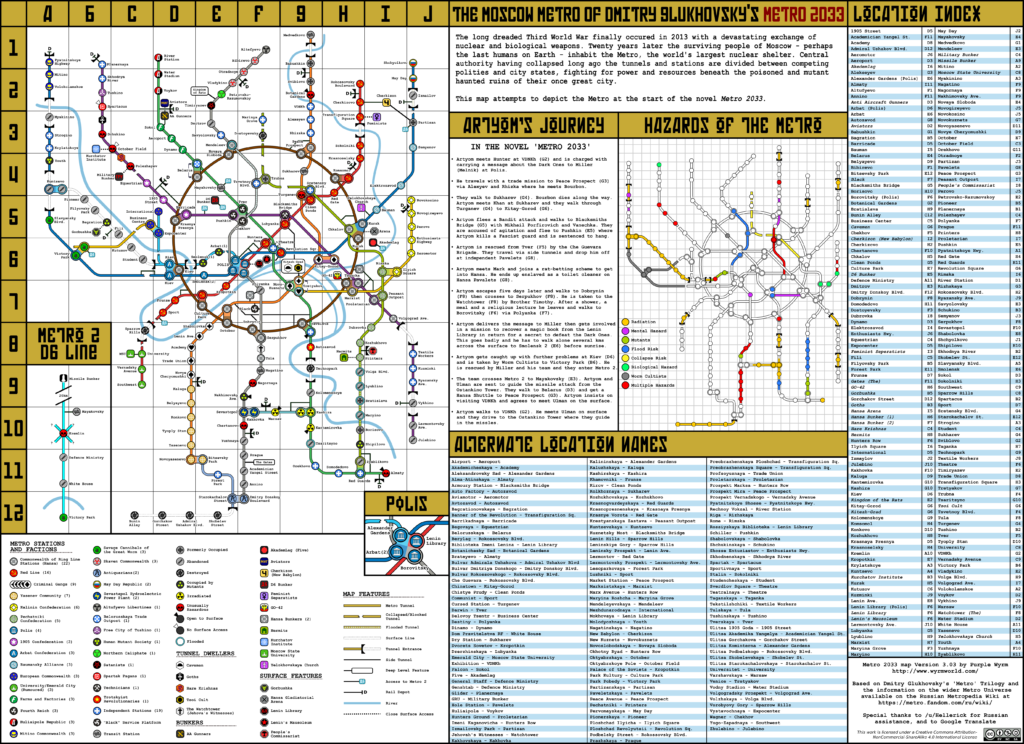
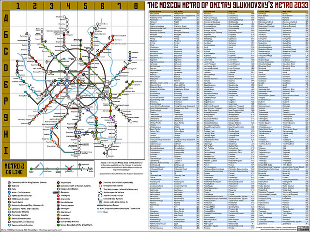
Some years back (about 6 I think?) I spent a fair bit of time putting together a map of the post-apocalyptic Moscow Metro system of Dmitry Glukhovsky’s Metro 2033 series. While this was received pretty well by both the cartographic and Metro communities I was never 100% happy with it – in particular the way it echoed the inaccurate depiction of interchanges from the official map – and I always intended to go back and revise it.

So now I have.

After many hours of studying Moscow’s geography and trawling my way through the Russian Metro wikia (with the assistance of Google Translate) I have redrafted and updated my map to produce what is undoubtedly (by which I mean ‘doubtedly’) the best English map of the Metro ever produced!

A miracle of rare device! A sunny pleasure dome with caves… wait, that’s not even CLOSE to accurate…
Seize-Seize the means of production! Yes-Yes!

As is my wont I’ve included some information from the expanded “Universe of Metro 2033” books by other authors, despite some of them being a bit silly (I’m still not quite over there being Skaven on the Serpukhovsko–Timiryazevskaya line). I’ve also used some content from the Metro computer game series, which is based on the books but takes a number of serious liberties with them (any version of Metro 2033 where Artyom doesn’t spend a week being forced to shovel human waste out of toilet pits simply isn’t Metro 2033!).

My next insane project is a redraft of the regional Moscow map I found on the Russian wiki, which is highly deficient in various areas. I will take some time off first however – at least until I stop waking up in the morning with the names metro stations echoing in my head (ТеатральнаяТеатральнаяТеатральная…)

Return to Brichester

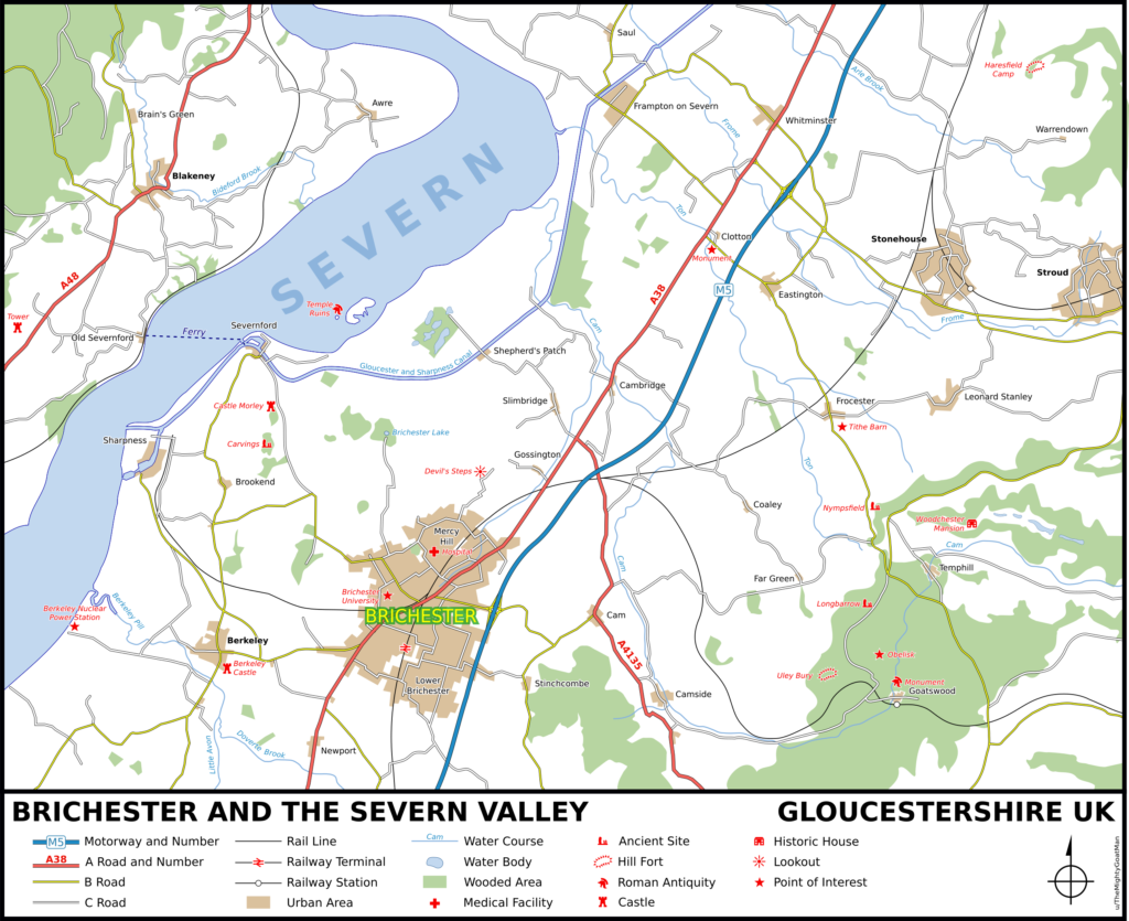
I have finally got around to finalising the updated version of my Campbell Country map that’s been sitting on my desktop for months.

The changes are pretty minor – basically just tweaks to fix a few discrepancies uncovered by a re-read of the source material. Brichester for instance only has one train station, located in Lower Brichester, Temphill is surrounded by woods, and there’s actually a road running out to the Devil’s Steps. There are also some carvings in the woods near Castle Morley – I think that’s it.

Anyway, here ’tis!

For info on my cartographic process see Brichester and Parts Beyond.

EDIT: And of course – the universe being perhaps not quite as bleak and hostile as Lovecraft thought but still a thorough pain the posterior – no sooner do I publish this updated map than I discover more geographic detail. “Brichester Lake”, the favoured abode of Gla’aki, should actually be named “Deepfall Waters”.

I discovered this fact courtesy of Justin Alexander over at The Alexandrian, who has come up with a fantastic solution to the limited geography of the Vale of Berkely that simply never occurred to me despite the puzzle pieces lying in plain sight.

Brichester and Parts Beyond

Update! A newer version of my Campbell Country map can be accessed here…

In early 1960’s Liverpool – a city still suffering the scars of the determined Luftwaffe bombardment of twenty years earlier – a teenage boy purchased a short story collection titled Cry Horror! from a sweet shop that also did a line in second hand books. The book was a re-titled print of H. P. Lovecraft’s The Lurking Fear and Other Stories, and the boy was a young Ramsey Campbell who would go on to become one of Britain’s greatest horror authors.

Totally infatuated with Lovecraft’s work, the young Campbell whipped off a series of pastiches set in H. P.’s fictional New England towns of Arkham, Kingsport and Dunwich. Then – in a remarkable act of self confidence – he sent them off to August Derleth, Lovecraft’s literary executor and publisher.

One would expect Derleth to have thrown these efforts straight into the bin, but apparently he saw something in them. He wrote back to Campbell telling him “in no uncertain terms” how to improve his writing, including advice to stop trying to imitate Lovecraft’s style, and to stop trying to set his tales in America. Campbell took this advice on board and shortly afterwards Derleth published one of his rewritten tales – with a revised title and some other editorial amendments – in a short story collection, and a few years later published an entire book of his stories – The Inhabitant of the Lake and Less Welcome Tenants.

Over the next few years Campbell continued writing Lovecraft inspired works, gradually developing his own voice and style. In the process he created his own version of Lovecraft’s New England, a fictionalised version of Gloucestershire’s Severn Valley sometimes referred to as ‘Campbell Country’.

The locales of Campbell Country and Lovecraft Country can be roughly matched. The university town of Brichester maps to Arkham. Temphill is Kingsport – despite the former’s inland location. Goatswood is an English version of Dunwich. Of course as Campbell continued his writing his versions moved further away from the originals.

So, why am I writing about all this? It comes down – as it usually does with me – to cartography.

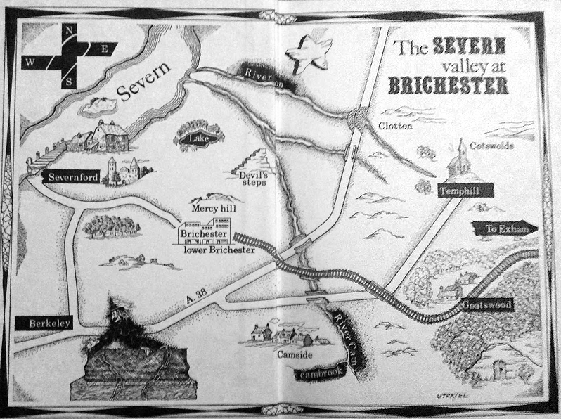
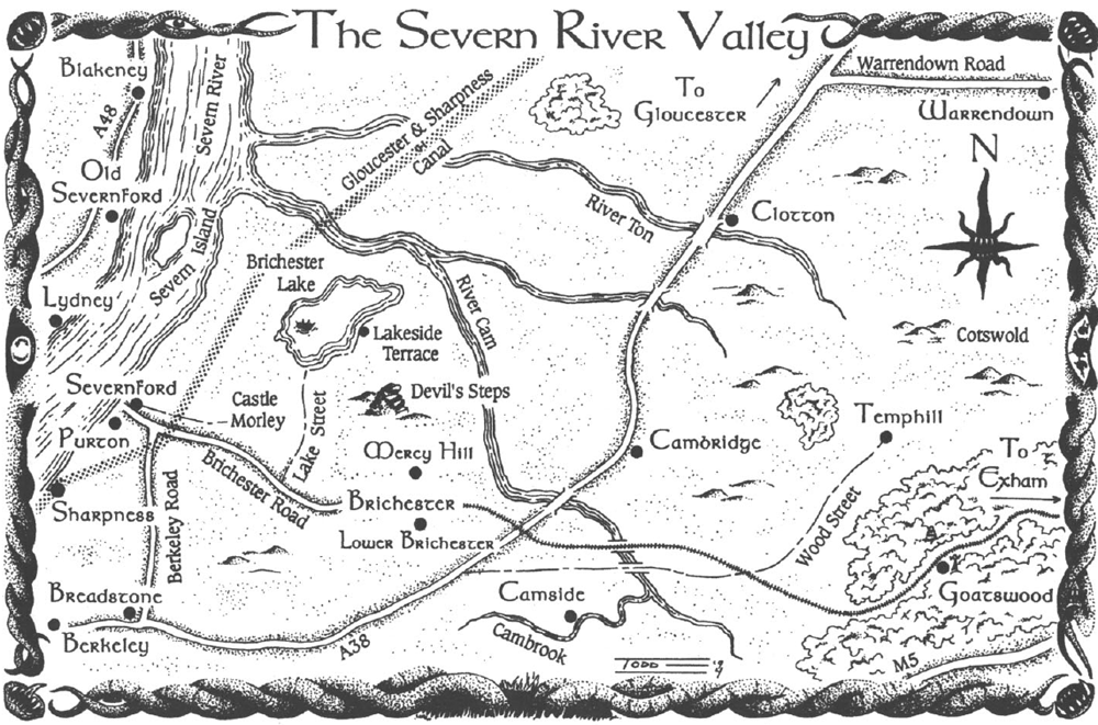
The Inhabitant of the Lake contained a map of Campbell Country, as did the 1995 tribute anthology Made in Goatswood. But both of them were sketch maps at best. The problem of developing a more detailed map of the Severn Valley has vexed me ever since I discovered Campbell’s oeuvre in the 1990s, and a few years back I decided to finally do something about it.

Map from "The Inhabitant of the Lake and Other Less Welcome Tenants" 1964
Map from “The Inhabitant of the Lake and Other Less Welcome Tenants” 1964

Map From "Made in Goatswood" 1995
Map From “Made in Goatswood” 1995

The primary problem with Campbell country is that there’s actually no room for it! It lies between the lower Severn River and the Cotswold hills – an area about 15 kilometres across. Brichester – a city easily the size of Swindon – would take up most of that space, leaving nowhere for the various desolate plains and creepy, isolated villages of Campbell’s stories. The map from Made in Goatswood even tries to fit the whole region in between the river and the M5 motorway, an area 6 kilometres across at the very widest!

On top of this, the Vale of Berkeley (as the region is properly known, the term ‘Severn Valley’ usually applying to areas north of Gloucester) is full of villages and urban developments, leaving ever less room for ominous woods and alien monuments.

So, I made two decisions. Firstly I would ignore matters of scale, and secondly I would free up space by replace existing locations with Campbellian ones.

So I got to work. But then (as so often happens) I got distracted. But then a few months back I found the files and decided to get back onto it.

In my revised geography Purton becomes Severnford with Old Severnford on the opposite side of the river. Claypits become the decaying hamlet of Clotton – it’s in the right place and I couldn’t resist the alliteration. The real world town of Cam is shrunk down to provide room for Camside. Ulley is converted to the sinister Goatswood and its valley filled with forest. Nympsfield becomes Temphill. The area around Haresfield (appropriate!) is depopulated and Warrendown plumped in the middle. Brichester Lake (and its inhabitant), the Devil’s Steps and Castle Morley are placed appropriately, and finally the city of Brichester is placed on the intersection of the railway and the A38 (which looks like this in reality). A few roads are moved, a few rivers redirected, and we’re done!

So here is my map of Campbell Country. I’ve no doubt made some mistakes and some incorrect assumptions, but overall I’m pretty happy with it.

Iä Gla’aki! Iä Iä Y’golonac!

Brichester and the Severn Valley

Cartographic Armageddon

Guess what? I’m back on that 40k Mapping thing again!

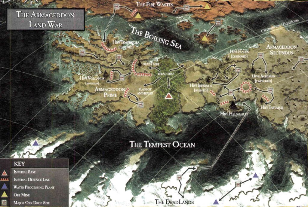
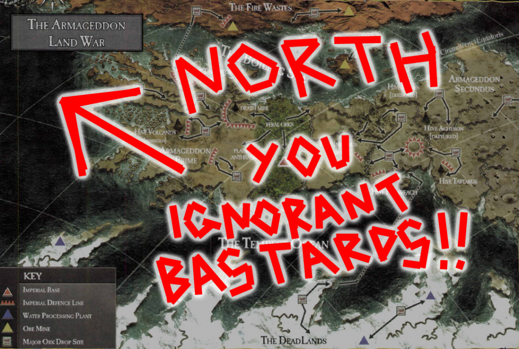
Behold Armageddon, one of the most fought over planets in the Imperium, with a Chaos invasion led by a Daemon Primarch, two Ork invasions led by Margaret Thatcher and the current general insanity caused by GW’s decision to move the plot forward under its belt.

Armageddon tired of GW's Cartographic Ignorance
Armageddon tired of GW’s Cartographic Failures…

It’s a pretty nice map, however ever since its publication everyone at GW has completely forgotten how to read it.

Look at those lines. That’s right, the curved ones. They indicate that we’re not looking at a flat map, we’re looking at some kind of globular projection. Furthermore notice that the lines are slanted – that means that we’re not looking at the map from a  cardinal direction (north, south, east or west), but at an angle. And hey! Look in the upper right hand corner! One of the lines is marked as the equator! This tells us that north is to the upper left!

NORTH IS THAT WAY!!!

Unfortunately this is something that has escaped the notice of GW’s writers and artists who have consistently read it as a flattened, north oriented map, even publishing redraws of it with an upwards pointing compass rose slapped on top – most notably in the recent reprint of Gavin Thorpe’s Annihilation Squad (a damn good read actually, despite the compass directions being all screwy BECAUSE NO ONE AT GW CAN READ A GODDAMN MAP!).

Perhaps the silliest aspect of this are the planet’s famous equatorial jungles. If we look at the map above we can see that this name makes sense – they sit right across the planet’s equator. If we go by the later maps however they’re just randomly plonked running north to south, giving one the impression that whatever Ordo Cartographica scribe first charted the planet was hitting the amasec really hard.

So, what to do about this all this malarkey (apart from making a ranting blog post that no one else will ever care about)? Why, redraft the map of course!

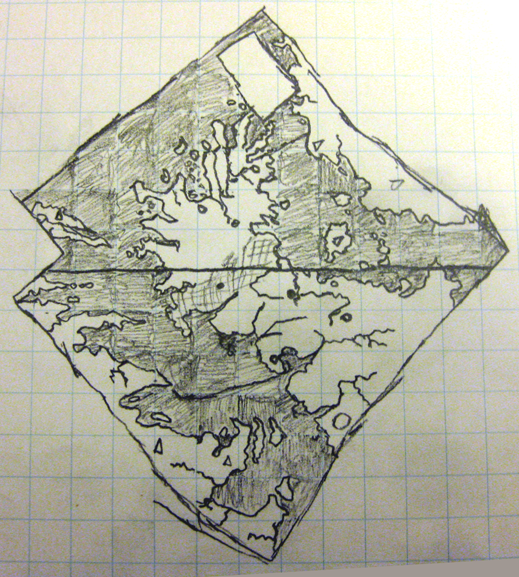
Now, this is a bit easier said than done. The globular projection adds all kinds of distortions and while I am sure there is software out there that can correct them in the twinkling of a nurgling’s eye I don’t have access to them. So I decided to go old school and resort to paper and pencil.

Step one was to make the map grid a bit denser. I did this by tracing the existing grid in Inkscape and then running additional lines between each of them, splitting each of the existing map squares into four. Step two was to grab a piece of graph paper and sketch in the details of each square…

armageddon_map_corrected
So there we have it! That’s what a flattened out, north oriented Armageddon map really looks like! Armageddon Primus is actually north of Armageddon Secundus and the entire continent is stumpier than the angled view suggests

So, I now expect GW to start using this corrected version immediately! ;D

EDIT: Yes, it is rather strange that the continent to the west (the Dead Lands) is completely frozen over while the central continent (at the same latitudes) isn’t. There’s a clue to this in that the eastern continent (the Fire Wastes) appear to be barren desert. This would suggest that Armageddon has a pretty severe axial tilt combined with some rather weird orbital characteristics – which given its ancient history (no spoilers, but go read The Beast Arises…) is actually rather plausible.

Meanwhile on Necromunda

Ah Necromunda! Hive world of hive worlds! Star of the Araneus Continuity! The planet so trashed that they’re refining the waste left over from the last time they refined the waste just to keep things going! How we love thee!

What the hell am I on about you ask? Predictably it’s Warhammer 40,000 again and in particular the relaunch of Games Workshop’s skirmish combat game Necromunda, set in the collapsing, polluted, gang-ridden underbelly of the planet’s largest hive city.

“But” you say “Necromunda was relaunched months ago! Why are you only babbling about it now?”. Good question. Well, maybe not such a good question because the Wyrmlog has been in a state of deep torpor for months. But still, what is my point? Have I bought the game and am engaged in an engrossing campaign with my friends?

Ha! Of course not! Do I look like I’ve sold a kidney?

(Really? Wow, I should probably eat some vegetables or something hey?)

Anyway, no I have not bought a copy because I plan on eating for the next few months. I have however been keeping an eye on the whole thing because I am a nerd and that’s what nerds do.

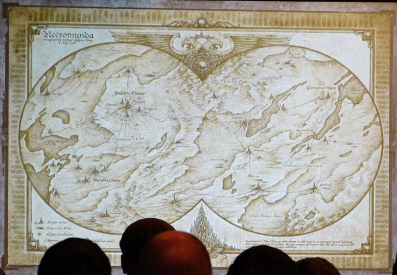
And in keeping an eye on the whole thing I stumbled across a series of photographs taken at the Horus Heresy/Necromunda Weekender event GW threw a month or so back. Among them was this…

Necromunda Map
Image Source – https://recalcitrantdaze.blogspot.com.au/

…which really got my sci-fi-nerd and map-nerd juices really running. A map of the entire planet!!!

Except… It’s really not…

As a piece of art it’s undoubtedly great. As a map it fails badly.

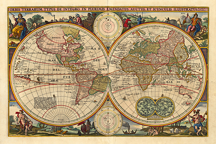
It’s clearly mimicking the look of an antique Nicolosi Globular projection map…

MAWO-62++World+Map+1670++Antique+Framed+Maps

…but the artist seems to have not understood how a globular projection works and just drawn the details as if it’s some kind of rectangular projection with bits chopped off to fit in the frame. This is particularly noticeable in that the east and west edges of the map don’t match up – water bodies just vanish off one side and don’t show up on the other! HERESY! CARTOGRAPHIC HERESY!

Faced with this insult to generations of map makers I had no choice. I had to redraw the entire thing properly.

I started by assuming that the original map is a equirectangular projection – not unreasonable I think given that that’s how most people think maps work. I expanded it on both sides to make room for a strip of land linking the east and west edges, and added space to the top and bottom to account for the poles. I then filled these spaces in with plausible detail (ie: made a bunch of stuff up).

With that completed I ran the result through NASA’s G.Projector tool to render it into a proper global projection. A bit of cleanup and labeling later, I ended up with this. Behold its Majesty!

f2

The Worldsump Ocean may be much larger than I show it and I had to squint to try and read some of the labels in the southwest section of the original, but overall I’m pretty happy with it.

The lesson to be drawn from all this? Never underestimate the lengths an Aspie will go to to correct problems in properties they care about! ;D

Tunnel Dweller

For the last couple of weeks I’ve been spending much of my time wandering the Moscow Metro system.

Not literally of course. I’ve merely been studying the crap out of it in order to produce a (hopefully) really good English Metro 2033 map.

I imagine there are plenty of really good Russian maps, but none of them appear to have been translated. All of the English ones I’ve been able to locate are sub-par at best. This situation could not stand, so I trawled the net for info, spent what seems like hours on Wikipedia and Google Translate, learned to read Cyrillic (sort of), and put together this miracle of rare frickin’ device.

Moscow Metro circa 2033
Behold its Majesty!

I’ve based it on the Metro as it was in 2002, since that’s when the first book was published. The Metro has been expanded since then but I’ve only included new lines and stations only if I can find evidence they’ve been mentioned in the series. Information from the computer games has been included only where it doesn’t conflict with the novels. I scraped together what information I could from the books that haven’t been translated into English and threw in a grid and index to make locating stations easier. Finally I included the original Russian names and various translations in the index, so no matter what version of the books you’re reading you should be able to find the stations you’re looking for.

People on Reddit seem to like it, which is all I can really ask for 🙂

Close Bitnami banner
Bitnami